Italian National Agency for New Technologies, Energy and Sustainable Economic Development

MEDIA - Press office ENEA
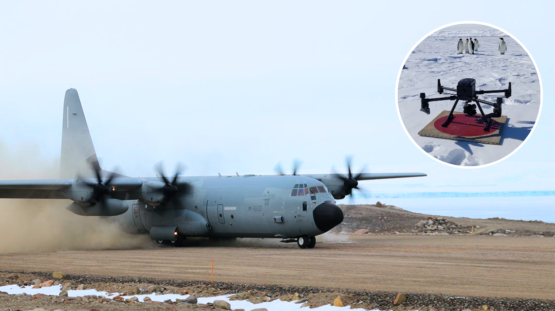
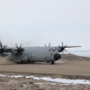
Antarctica: ENEA drones monitor new Italian landing strip
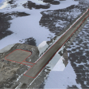
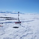
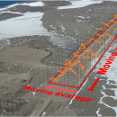
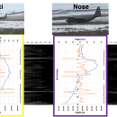
Drones, lasers, software for processing images, videos and 3D models, supported by the CRESCO supercomputer, are the innovative technologies used in Antarctica by ENEA technicians to study the effects of aircraft landings and the Antarctic winter on the Boulder Clay airfield. Designed and built "on land" by ENEA and the Italian Air Force near the Italian Mario Zucchelli base, this semi-prepared runway will serve, once fully operational, to transport people and goods for research expeditions conducted by ENEA, Cnr and OGS[1].
The use of drones, combined with artificial intelligence applications, allows to perform a vast range of investigations in a "hostile" territory like the polar one, while ensuring greater safety for personnel, reducing the environmental impact of research due to low energy consumption, possibility of reaching remote or inaccessible sites, accuracy and repeatability of surveys.
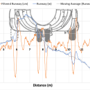
“The drones, which we have used as decision support and monitoring tools since the early stages of construction of the runway, have detected values that confirm what was planned, giving us an important structure to manage the entrances and exits from Antarctica in a more flexible and efficient manner.”, explained Gianluca Bianchi Fasani of ENEA, technical manager and expedition leader of the 39th Italian expedition to Antarctica. “This will not only benefit the National Antarctic Research Program (PNRA) – he said – but all the research stations t in the Ross Sea area (South Korea, Germany, China, New Zealand), contributing to the development of scientific activities".
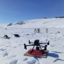
“Drone usage in Antarctica is regulated internationally and requires to pass a test and the adoption of particular precautions. In fact, in the polar territory the magnetic field is very weak and the value of the magnetic declination[2] is high. This condition leads to navigation problems, even the risk of losing control of the drone", said Riccardo Scipinotti, ENEA researcher of the Antarctic Technical Unit and currently expedition leader at the Italian-French "Concordia" station, at over 3 thousand meters on the Antarctic plateau. “Furthermore – he said – since low temperatures affect the the drone's batteries, they must be equipped with heating systems which, although reduce their duration, guarantee their life cycle. Lastly, we be prepared to sudden gusts of wind, frequent in Antarctica, which may affect the stability of the drone."
Given the large amount of data acquired by the drones and the need to have the processing results quickly, a supercomputing cluster composed of 8 computing nodes from the ENEA CRESCO clusters was set up at the Mario Zucchelli base. “The supercomputer allows you to immediately analyse images and verify the correctness the data, without having to wait to return to Italy for processing,” explained Samuele Pierattini, researcher of the ENEA Division for the Development of IT Systems and ICT, who contributed to the activity.
During the latest Antarctic expeditions, drones were used to periodically check the conditions of the facilities, monitor a frozen lake in the Boulder Clay moraine, document research activities and conduct topographic/cartographic surveys of the Mario Zucchelli Station and surrounding areas.
Photogallery
Notes
[1] The 39th Italian scientific expedition to Antarctica is currently underway. The Italian missions in Antarctica, funded by the Ministry of University and Research (MUR) as part of the National Antarctic Research Program (PNRA), are managed by the Cnr for scientific coordination, ENEA for planning and logistics at the Antarctic bases and the National Institute of Oceanography and Experimental Geophysics (OGS) for technical and scientific management of the icebreaker Laura Bassi.
[2] Magnetic declination is the variable angle formed between the direction of true (geographical) North and magnetic North.