Italian National Agency for New Technologies, Energy and Sustainable Economic Development

MEDIA - Press office ENEA
Environment: Climate service from ENEA to map flood-prone areas
Some coastal areas in Tuscany, Sardinia and Lazio already available
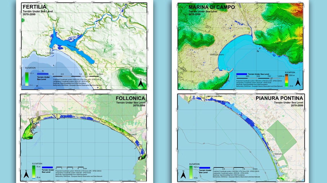
ENEA has developed a new service to map coastal areas at risk of flooding due to climate change that combines high-resolution models[1], satellite technologies[2] and field surveys. The new climate service was developed by teams of researchers consisting of climatologists, GIS experts, oceanographers and geologists and was presented at the 21st International Union for Quaternary Research (INQUA), one of the most important international conferences on Quaternary science[3] held recently in Rome. To date the maps of Follonica-Piombino and Marina Di Campo in Tuscany, Fertilia-Alghero in Sardinia and Circeo National Park (Latina-Sabaudia) in Lazio have been completed (fig. 1, 2, 3), while those of the coasts of La Spezia, Rome, Naples, Brindisi, Taranto and Cagliari are being finalised.
The new mapping service is intended to provide public decision-makers and central and local administrations with information on the evolutionary trends of the region in order to plan climate change adaptation strategies[4].
"The results of our studies have shown that by the end of the century the assets most at risk of flooding will be wetlands, backshore and backdune areas, and some maritime infrastructure", noted Sergio Cappucci of the ENEA Laboratory of Technologies for Structure Dynamics and Seismic and Hydrogeological Risk Prevention. "As far as the wetlands and backshore areas are concerned", he added, "the risk of flooding with respect to the current average sea level is due to low elevation and subsidence, while for coastal infrastructure such as harbours, defence works, jetties, and reservoirs, the cause seems to be the natural sinking of the seabed”.
Specifically, the innovative approach consists of three phases: in the first, using digital terrain models from some of the national and European platforms (such as the National Cartographic Portal for digital models and the Copernicus program for vertical movements of the earth's surface), coastal areas that will be most vulnerable to sea level changes in the coming decades are identified. The second phase involves an in-depth assessment of the categories of assets most exposed to flooding.
"Thanks to the availability of Digital Terrestrial Models (DTM) from the period 2008-2012 with very high resolution data for almost the entire national territory (from 5x5 m down to 1x1 m), we are able to perform preliminary analyses on vast portions of the country in a relatively short time", explained Gaia Righini and Lorenzo Moretti of ENEA's Division of Models and Technologies for the Reduction of Anthropogenic Impacts and Natural Risks.
"The IPCC's sea-level rise projections lack the regional details that are crucial for studying an area as 'special' as the Mediterranean", pointed out Roberto Iacono of the ENEA Climate Modelling Laboratory. "In this context, the development of the new approach makes it possible to capitalise on the efforts that the scientific and European communities are making to share platforms of environmental data and information and to work towards a high-resolution open access climate service with increasingly reliable and realistic scenarios in order to assess the future impacts of climate change and plan appropriate prevention and adaptation strategies".
The third phase consists of field surveys. In fact, measurements, sampling, dating and geological surveys make it possible to improve the quality of data and digital models of the earth's surface, but also to identify the various components that contribute to the scenarios indicated in the flood maps and that satellites are not yet able to detect individually, i.e. tectonics, subsidence, lithospheric sediment loading and compaction, glacial adjustment and changes in groundwater as a result of water exploitation.
"As the title Time for change of the INQUA 2023 Conference reminds us, it is indeed time for a change, and thanks to this new approach ENEA can quickly provide a contribution to this inevitable change of pace with respect to the methodologies used until today, with initial assessments for the entire country and subsequent calibrations for a more precise definition of the areas where the probability of flooding must be considered in detail, to avoid risks to populations and production areas", concluded Sergio Cappucci.
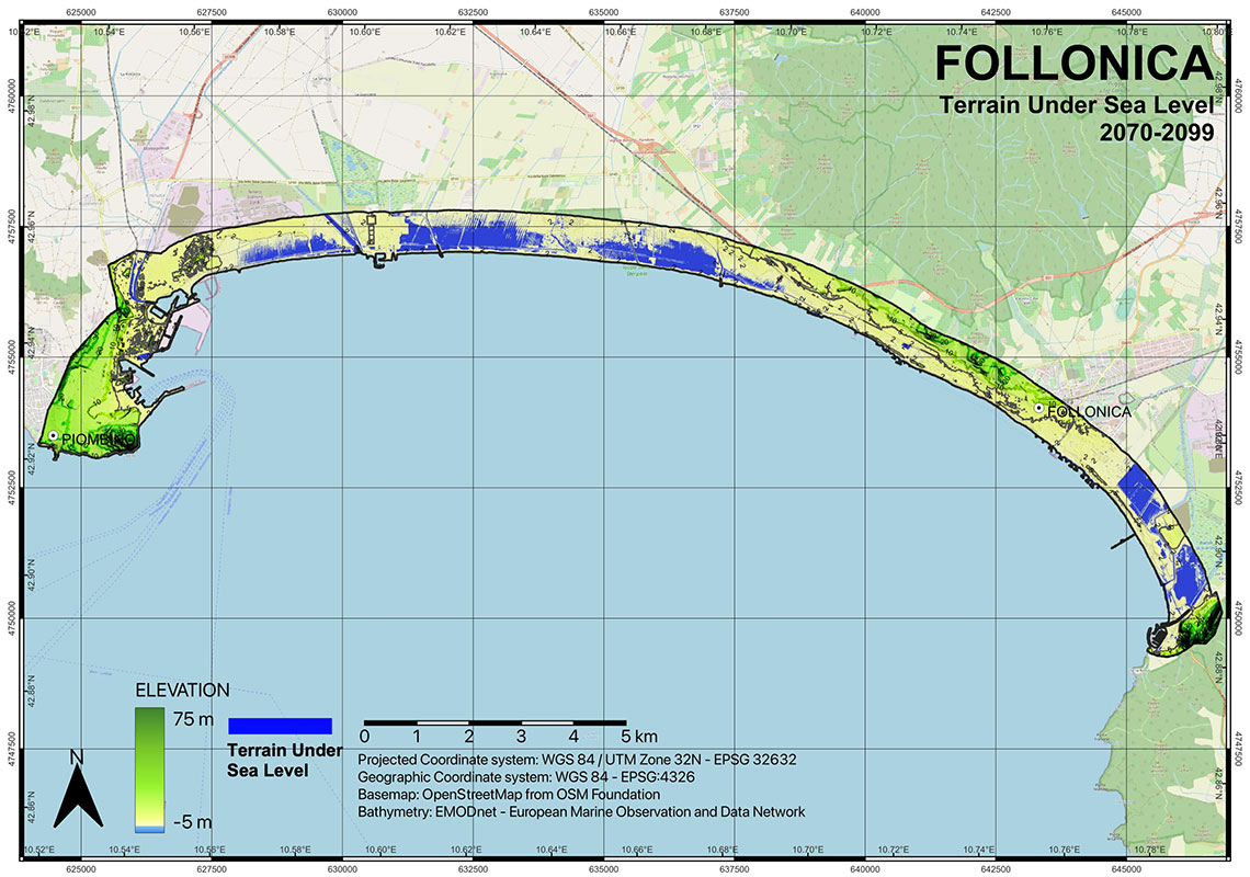
Figure 1. Preliminary flood map of Follonica-Piombino for the period 2070-99070-99
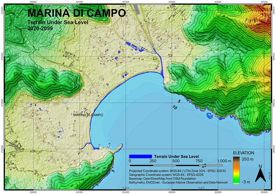
Figure 2. Preliminary flood map of Marina di Campo for the period 2070-990-99
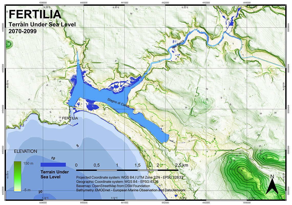
Figure 3. Preliminary flood map of Alghero-Fertilia for the period 2070-99
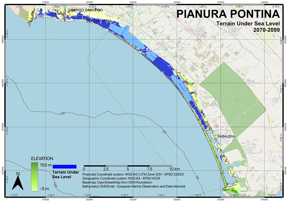
Figure 4. Preliminary flood map of Latina-Sabaudia for the period 2070-99
For more information:
Sergio Cappucci, ENEA - Laboratory of Technologies for Structure Dynamics and Seismic and Hydrogeological Risk Prevention,
Cappucci S., Iacono R., Immordino F., Moretti L., Palma M., Righini G., Sannino G., Evolution of coastal environments under inundation scenarios using oceanographic models and remote sensing data. Book of Abstracts of INQUA XXI Congress.
Notes
[2] Variations of the earth's surface recorded by satellites with a 100x100m mesh.
[3] Quaternary Sciences study the recent evolution of the planet, landscape and ecosystems and are indispensable for the reconstruction of ongoing natural processes, to distinguish between global changes due to human activity and natural phenomena and understand which resources are truly renewable, in order to guarantee an ecological and energy transition compared to our current development model. These are issues with a scientific and applicative scope fundamental for understanding the developments of the most recent Anthropocene era, during which man, with his activities, has managed to impact geological processes, the water resource, the climate and the landscape with territorial and structural modifications.
[4] Adaptation to climate change means anticipating the adverse effects of climate change and taking appropriate action to prevent or minimise the damage they can cause.